
Social media has condensed visiting the Faroe Islands into a series of iconic photos. Scroll through Instagram, and it seems like every tourist goes to the same idyllic turf-roofed house and of curiously-shaped sea stacks. You’ll probably see these same sights on your Faroe Islands vacation. But finding the exact perspective of these images can be tricky.
This post will clarify how and where to find the most photographed landscapes in the Faroe Islands. While most of them are easy to capture with a regular camera (or even a phone camera), there are a few that are best shot with a drone. We offer a comprehensive guide of the photography equipment you’ll want to bring with you in our Faroe Islands packing list.
What’s Included:
- Drangarnir
- Gásadalur
- Sørvágsvatn
- Tórshavn
- Saksun
- Gjógv
- Kallur Lighthouse
- Rituskor
- Akraberg Lighthouse


Drangarnir
This duo of sea stacks between the islands of Vagar and Mykines are some of the most photographed in the Faroe Islands. While they’re called Dragarnir, their names are Stóri Drangur and Lítli Drangur – big and little sea stack.
Where to get the shot: While there are multiple points where you can see them, getting the most iconic view requires a hike. This hike goes over private land and you’re required to pay to hike with a local guide. The hikes depart from the Effo gas station, right by the harbor of Sørvágur. The hike will end at the iconic photo spot, and if there’s any doubt about where that is, you can ask your guide.
Scheduling prevented us from doing this hike, but everything we read about it raved about the experience.
Other details: This is a spot where you can use your drone, but as it’s exposed in the ocean, the winds can get too strong to fly. You could bring a tripod – but do you really want to hike with it?

Gásadalur
The image of a waterfall tumbling from the edge of an idyllic village over crags and rocks into the ocean isn’t one you soon forget and even more incredible to see in person. Whether you choose to hike to the waterfall or to drive to it, visiting this gorgeous spot is a must-do on your Faroe Islands itinerary.
Where to get the shot: To get the best photo, head to the edge of town and across the inlet. There are multiple spots around the area where you can get an excellent area. There is a viewing area at the end of Inni á Bakka (Look for a small parking area with a bench on the road in). Or hike out of town along the road to a point just before the Gásadalur hiking trail for a higher angle perspective.
Other details: If you’re choosing to drive to the waterfall, it’s a great place to use your tripod. You can use a drone, as the waterfall is further than 150m from the town. But be mindful of others around you also trying to enjoy the waterfall.

Sørvágsvatn
Not only does Sørvágsvatn provide an easy, gorgeous hike, it’s also one of the most photographed destinations in the Faroe Islands. When viewed from the proper angle, you’ll see that the lake is perched on a cliff over the North Atlantic.
Where to get the shot: Follow the trail around the lake and look for a well-trodden, but narrow path that heads up a small incline. You’ll know you’re at the right place when you see stairs etched into the hill side. If you’re walking away from the town towards the ocean, this trail will be on your left.
Continue on this trail for a few minutes, until you reach an oval divot worn into the ground. Stand here, and you’ll be able to get the photo of the lake above the water.
For another view, sit on the right side of the plane when landing in the Faroe Islands. If the weather is clear, you’ll have a fantastic view of the lake teetering above the ocean. Hiking out to Trælanípa is another option, you can find the hike details in the official Faroe Islands hiking guide.
Other details: This shot is a relatively easy one to get and requires no special equipment other than your camera.
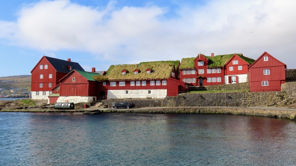
Tórshavn
While the Faroe Island’s capital Tórshavn is the largest city in the archipelago, it offers scenes that seem positively quaint in comparison to major cities. By far, the most photographed area of Tórshavn is the parliament district. With their bright red facades and turf roofs, these are probably the most picturesque government buildings you’ll ever see.
Where to get the shot: You should dedicate time to exploring the downtown area, but to get the best photo of the parliament buildings, walk to the harbor, east of parliament. Find the jetty where the ferry to Nolsoy boards (look for Bursatangi street). From here, go to the end of the jetty, which looks straight towards the parliament buildings. When you reach the water, you’ll have a great panorama of the entire district
Other details: You won’t need any special gear for this, even a phone camera turned horizontally or shooting a panorama will work like a charm to get this shot.
Do check the ferry schedule to Nolsoy, which may interfere with your photo.
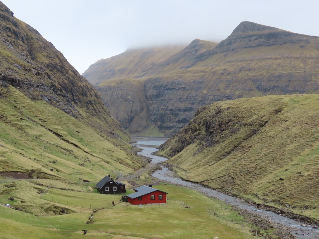
Saksun
While there are certain images of Saksun that have become iconic (and not always for the right reasons), there’s hardly a corner of this charming remote village that won’t make you reach for your camera. The road from Hvalvík to Saksun is called a Buttercup Route, which designates a particularly scenic area. This drive is probably the most jaw-dropping of all the Buttercup Routes in the Faroe Islands. If you have a GoPro that mounts to your car or windshield, now is the time to use it.
Once you reach Saksun, you’ll find that there are a lot of signs around reminding you not to use drones and not to walk on private property. Unfortunately, the urge to take the most iconic, idyllic photos have driven some people to walk on private land to get a shot of a now photo-famous cabin. There’s no need to as there are so many other gorgeous spots.
Where to get the shot: For the best angles, you’ll want to start walking down into the valley toward the trailhead of the hike that takes you to the lagoon. Along your way, you’ll have great views of some cabins set against mountains.
Also take time to walk into the churchyard, which provides more great views of the village and towards the lagoon.
Other details: While drone footage of Saksun would look incredible, it’s unfortunately off-limits.
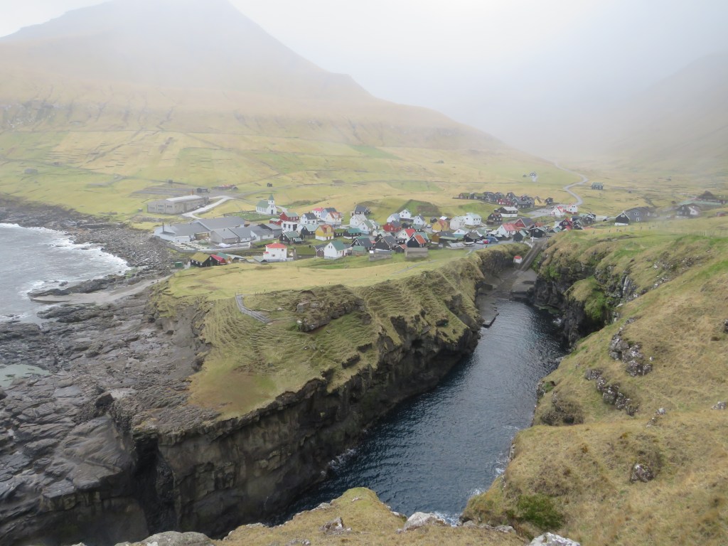
Gjógv
A deep gorge bisects the center of Gjógv, giving it an atmosphere of grandeur and idyll. While there are plenty of lovely corners for photographs throughout the town – there was a fashion shoot going on when we visited – the money shot is a short walk up a hill away from the buildings.
Where to get the shot: From the water, head back up into the town until you reach the public toilets and a cafe. Take the grass trail behind the cafe that snakes off above the water and follows the edge of a sheep fence. After walking for about ten minutes, you’ll reach a gate for a private hiking trail. Turn around and take a few steps back toward Gjógv and you’ll have your photo. There are visible dirty patches in the ground where most people stand to get their photos.
Other details: While this spot can get windy since it’s so exposed, it’s also a great location for breaking out a tripod, if the conditions aren’t too bad. Unfortunately, you’re too close to town to be able to use a drone. If your camera or phone camera lets you take wide-angle panorama shots, this is a great spot to use that feature.
Also don’t miss taking the steps down into the gorge from in front of the café. Photos at the bottom, near the water can be very atmospheric.

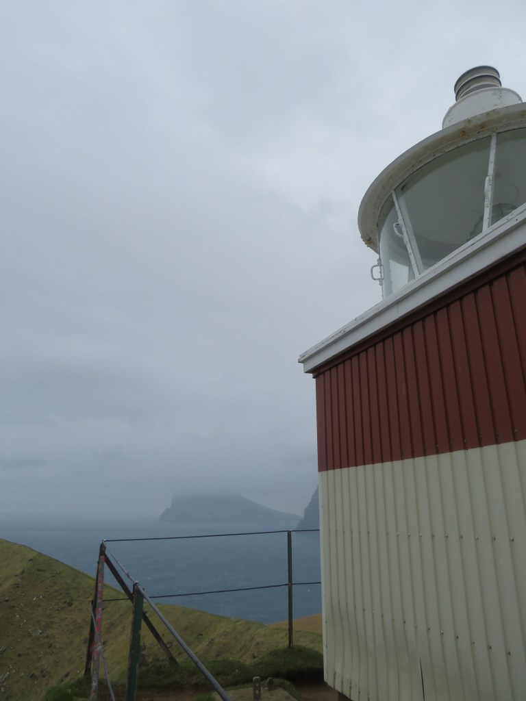
Kallur Lighthouse
At the very north tip of Kalsoy, an island in the northern reaches of the Faroe Islands that you can only reach by ferry, you’ll find a lighthouse perched on a blustery cliff. It’s a real end-of-the-world feeling. Perhaps unsurprisingly, it’s also one of the most iconic images of the Faroe Islands.
Where to get the shot: To reach the lighthouse, follow the instructions that we outline in our Faroe Islands hiking guide. Once you’ve arrived at the lighthouse, head for the promontory jutting into the ocean towards the north. Walk carefully until you’ve reached the well-trodden circle at the end of the path.
Other details: While it’s tempting to use a tripod here, the gusts of wind mean that a camera will be the most practical option. Drones also will struggle with the high winds.
Unfortunately, because of its location, there can be brutal gusts of wind around the lighthouse. When the wind kicks up, heading out to the promontory may not be the best idea. Instead, hike away from the lighthouse and towards the mountain peak until you reach another little divot (not more than 100 feet away). You won’t be able to get the iconic photo of the lighthouse against the jagged cliff, but you’ll still get an impressive shot of the chopped-off mountainside. You will also be standing on the spot where the James Bond Tombstone was briefly located.

Rituskor
Rituskor might be a bit off the tourist track on Suðuroy, the Faroe’s southernmost island, but its striking cliffs have made it one of the most photographed spots in the archipelago. You’ll need to take a ferry to reach the island, and once you arrive, it’s a twenty minute drive to Sandvik, the closest town to Rituskor.
Where to get the shot: You’ll need to hike from the outskirts of Sandvik to reach Rituskor. The trailhead starts at the end of Heiðavegur, the first road that turns left just as you enter Sandvik. The road is rocky and the general guidance as to where the trail starts is to go as far as your car can comfortably drive, park it, then walk.
You’ll follow the road until it reaches the cliff edge and switches back. At this point you will want to follow the switch back for a hundred meters and then turn right and start heading up the hill. You may see worn trails that you can follow, but they will quickly become indistinct.
After about twenty to thirty minutes of climbing, up the hill and slightly towards the water, you’ll reach signs that warn you to stay away from the edge and the gorge below. A metal rope encircles the hidden gorge edge so that you do not fall in. Follow this rope back towards the island, around the end of the gorge, and then back towards the water on the other side of the gorge. Continue until you reach a wooden bridge. You could keep going further, but we think the money shot is just at the bridge’s base. Look northeast to see Ásmundarstakkur, one of the Faroe Islands’ most famous sea stacks, and the tallest.
Other details: This is a perfect spot to use your drone, so long as the weather is on your side. We recommend flying over toward the sea stacks, Ásmundarstakkur, as well as through the gorge. Beware of birds, who, if annoyed, may become territorial and attack your drone. Since you’re far away from the sea stacks, it’s also a good place to use a tripod, though the hike up makes this a less practical option.


Akraberg Lighthouse
The location of this lighthouse would be reason enough to visit. It’s located at the southernmost tip of the southernmost island in the Faroes. Jutting out into the ocean, it’s a view that encapsulates the edge-of-the-world atmosphere that the archipelago does so well.
Where to get the shot: Drive past the town of Sumba following Akrabegsvegur until you reach the end of the road. Along the way you’ll pass a radio tower, which RAF soldiers in world war two updated to include radar and scan the water and air for enemy ships. There are also some roadside signs about the history of the local Frisians.
Once you’ve reached the end of the road, head to the small paved lookout point, which has metal guard rails around it. Lean over and take your photo.
While the land between the lookout point and the lighthouse is private, if you meet the local landowner, you can ask to head out to the lighthouse itself. Follow the trail between the sheep pens and then along the cliff edge until you pass the lighthouse. Peak over the edge of the cliff to see the fog horn house and turn back around to get your shot of the lighthouse against the picturesque farm and rolling hills.
Other details: This area is technically okay for drones to fly, but as you’re right by peoples houses, we advise against it. A tripod can be helpful, and since there’s no hiking it’s easy to grab from your car should you decide you want to use it.

One thought on “Faroe Islands Photography: Where to Get the Most Iconic Shots”